
Science Bulletin: Quantifying the major drivers for the expanding lakes in the interior Tibetan Plateau
DOI: https://www.sciencedirect.com/science/article/pii/S2095927321007027
Supplementary data:https://doi.org/10.1016/j.scib.2021.11.010
The interior TP (ITP) contains more than 60% of the total lake water storage across the TP (Text S1.1 online). Owing to its large area and sparse observations, our knowledge of regional hydrology and the resulting lake water balance is very limited. To better understand the underlying drivers of lake dynamics, it is necessary to accurately estimate the closed-basin hydrology and the balance between four hydrological components (lake inflow, precipitation, evaporation and water storage changes). Of these, lake inflow comprises several key components (e.g., rainfall-runoff, SGM), which need to be separated with the aid of a hydrological model. Combining the new generation hydrological models with remote sensing products provides a unique opportunity to test model performance with respect to several hydrological-related properties, such as land surface temperature, snow depth, and lake water storage.
Here, we examine the water budgets of the ten largest endorheic lakes (with areas >500 km2) in the ITP (Figs. 1a, S1 and S2, and Table S1 online), using long-term (1979–2016) hydrological simulations at the lake basin-scale. We apply a calibrated and verified distributed cryosphere-hydrology model (water and energy budget-based distributed hydrological model, WEB-DHM), coupled with a three-layer snow module and frozen-ground physics scheme (WEB-DHM-SF) (Text S1.3.1 online). The contributions of various components (i.e., SGM, rainfall-runoff, lake surface precipitation, and lake evaporation (Ew)) to lake water storage change (LWSC) were individually quantified. Our study provides a quantitative assessment of lake volume changes and their driving mechanisms, yielding deeper insights into the role of internal hydrological processes and the changing cryosphere in shaping lake changes.
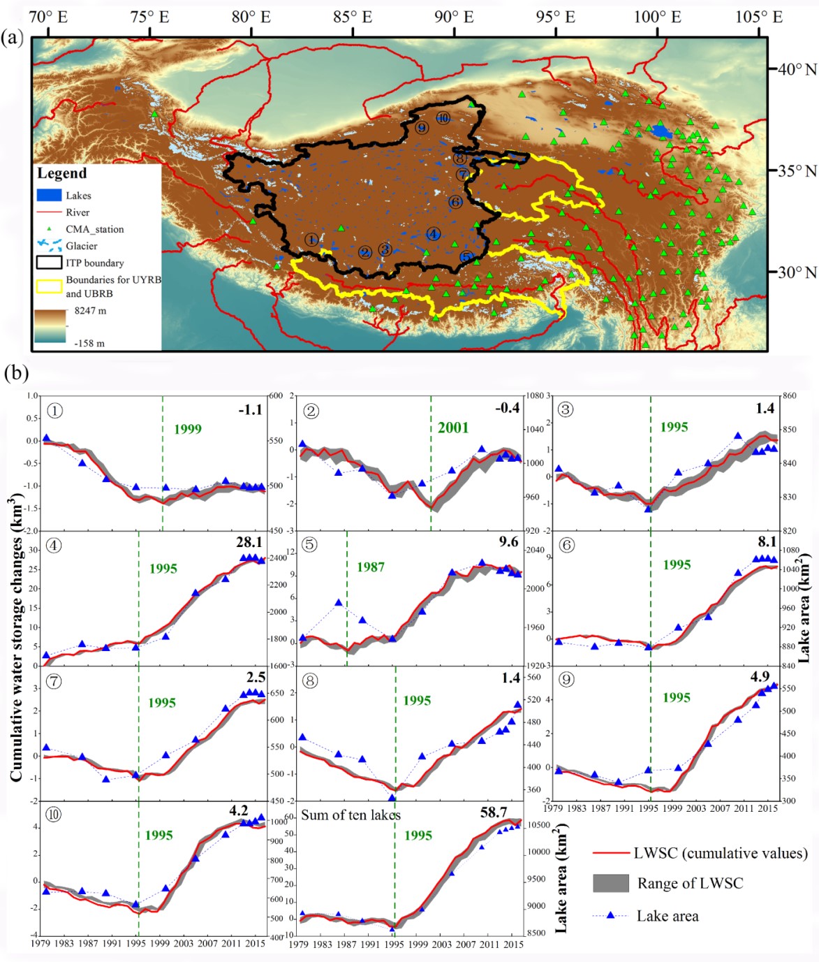
Fig. 1. Locations of the ten studied lakes across the interior Tibetan Plateau, and their simulation-based annual lake water storage change (LWSC) from 1979 to 2016. (a) The distribution of studied lakes in the ITP (individual lake basins can be seen in Fig. S1 online). ① Nganglaring, ② Zharinamco, ③ Tangra Yumco, ④ Seling Co, ⑤ Nam Co, ⑥ MC&DC, ⑦ Ulan Ula Lake, ⑧ Xijir Ulan Lake, ⑨ Aqikekule Lake, ⑩ Ayakeku Lake. MC&DC represents Dorsoidongco and Chibzhang Co, which are now considered to have merged into one lake following expansion. UYRB (upper Yangtze River basin) and UBRB (upper Brahmaputra River basin) are adjacent basins where the WEB-DHM-SF model has been successfully applied. (b) Time series of the simulation-based annual LWSC of the ten lakes. The shaded gray areas represent the range of LWSC estimates (the annual maximum and minimum values). The blue triangles show the changes in the lake area obtained from available datasets (from Ref. [6]) in the corresponding period. The green dashed lines and labelled years indicate the transition years of each lake (except Lake Seling Co). The numbers in the upper right corner are the cumulative LWSC values (km3) of each lake in 2016. The inset labeled “sum of ten lakes” shows the total LWSC of the ten lakes.
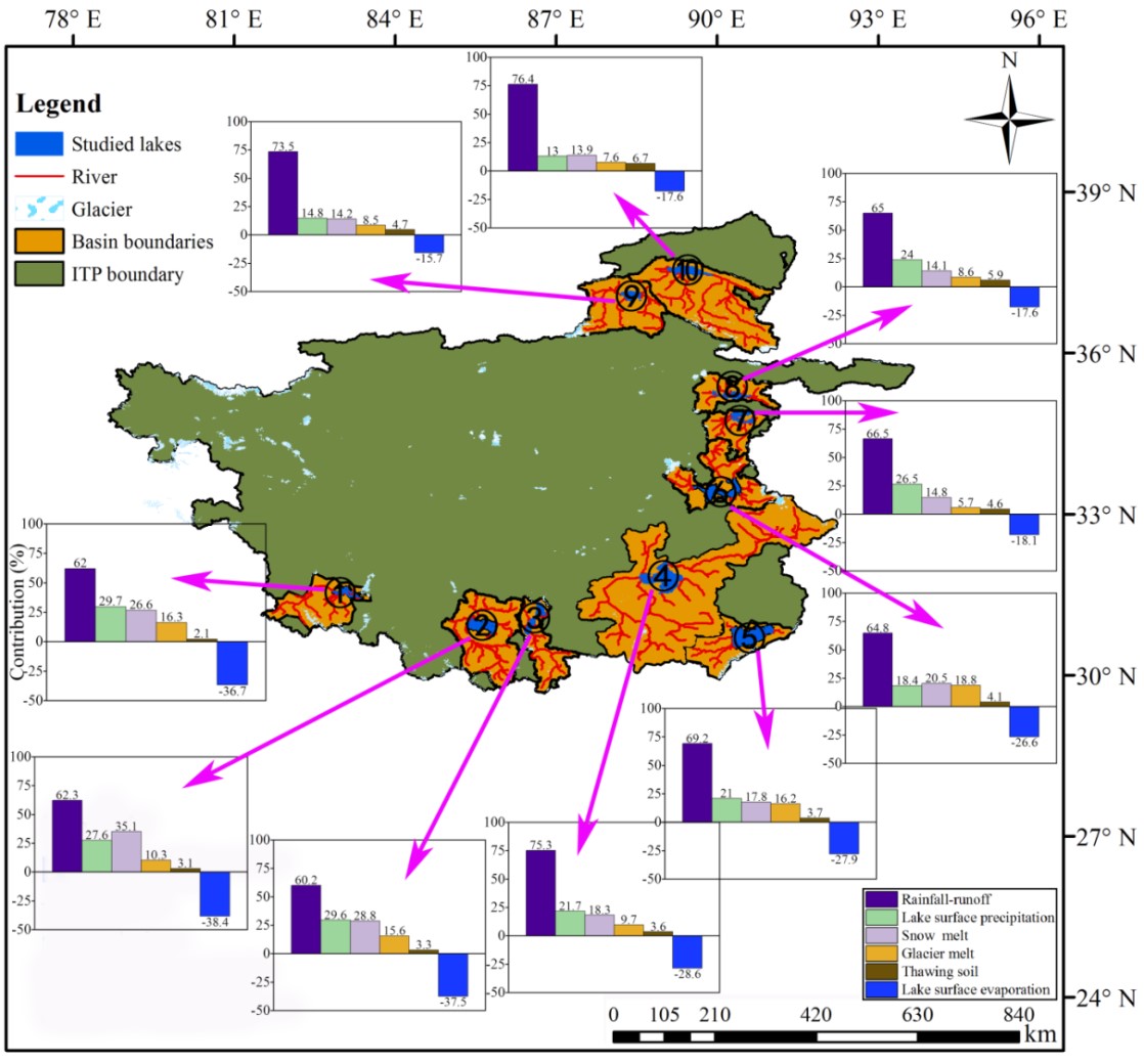
Fig. 2. The contributions of specific components to LWSC of the ten lakes across the interior Tibetan Plateau from 1979 to 2016.